Home page
» REGIONS
» About regions
About regions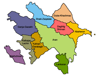 Baku-Absheron region
This region mainly consists of Absheron region. This economic region includes Absheron, Khizi administrative regions, Baku and Sumgayit cities and have very suitable economic- geographical positions. Total area of this economic zone is 5.9 thousand sq. kms and covers 7% of the territory of the country. The relief of the economic region consists of hills, foothills plains and low mountains. Dry subtropical climate is characteristic for this region.
Absheron economic region has the developed infrastructure. The most important railway, road, marine and air lines of Azerbaijan pass through the territory of this region. Location of the territory at shores of the Caspian Sea increases the opportunities of expanding of its transport links. Most kind of transport means function in the economic region.
Economic region, at the same time has the wide net of the social objects. Scientific-research institutes, higher schools, big sport centers, country-wide important medicine establishments and other social infrastructure function here.
Climatic-balneology condition of the economic region allows setting beach zones along the shores of the Caspian Sea.
Aran (Lowland) region
Lowland region covers Aran (lowland) economic region. This economic region covers administrative regions of and cities of Aghjabadi, Aghdash, Beylaqan, Barda, Bilasuvar, Goychay, Hajıqabul, İmishli, Kurdamir, Neftchala, Saatlı, Sabirabad, Salyan, Ujar, Zardab and Shirvan, Mingachevir, Yevlakh cities.
Aran (lowland) economic region has suitable economic-geographical position. Total area of the economic region is 21.43 thousands sq.km and covers 24.7 % of the country’s territory. More than half of territory of lowland economic region consists of plains located below the sea level. Only surface of areas of economic region adjacent to mountains are sloping. Dry subtropical climate is mostly characteristic for the region.
Lowland economic region is located on the important highways of the country (railway and road). Transport lines connecting Baku city with main economic regions of the country, Georgia, Iran and Turkey pass through territory of this region. Recent increase in international cargo transportation has increased the importance of these roads. Yevlakh-Baku air line also functions.
Western region
Suitable natural condition and economic-geographic position of the economic region had played the important role in settling of the population here. Total number of the population amounts 1103.3 thousand persons, which is 13.6 % of the country population.
Ganja-Gazakh economic region occupies the second place for its economical importance in the country. The second industrial region of Azerbaijan gives 12-13% of the industry output of the country. Industry of the economic region consists of extractive and manufacturing fields. Enterprises of extraction of raw of ferrous and non-ferrous metals and its primary manufacturing are located in the Ganja and Dashkasan. Heavy industry occupies important place in the economy of the region. Machinery, device manufacturing, manufacturing of communication equipment, repair of cars and agriculture machines and etc establishments are located in the economic region and transport system plays the important role in the complex development of the Ganja-Gazakh economic region. The region is located on the railway and highways connecting Azerbaijan with Georgia and Black Sea shores. They are joints of Ganja, Kazakh and Aghstafa are basic transport junctions. Republican important airport is located in the Ganja city. Pipeline for transportation of oil and gas from the Caspian Sea to the world markets passes through the territory of the region. Suitable natural condition, pure climate, picturesque mountain and forest landscape, medicinal effective mineral springs of the region allows creation of the leisure and curing establishments of international significance. Goy-gol and Hajıkand resorts have been established at height of 1566 m. above the sea level. Naftalan resort is world-wide important complex.
Social infrastructure of the region plays the important part in meeting many social-cultural needs (healthcare, scientific-cultural and education) of the population settled here, in social-economic development of northern-western region of Azerbaijan. Scientific centre of the National Academy of Sciences of Azerbaijan, scientific research entities function in the Ganja.
Southern region
Southern region mainly covers Lankaran economic region. Lankaran economic region of Azerbaijan Republic is located in the south-east of Azerbaijan and consists of territory of the administrative regions of Astara, Jalilabad, Lerik, Masally, Yardimly and Lankaran. Economic region has the border with the Caspian Sea in the east, with Islamic Republic of Iran in the south and west. Total area of the economic region is 6.08 thousand sq.m with 7% of the country territory. Territory of the region is divided according to relief features into two parts consisting of Lankaran plain (lowland) and Talish Mountains. 26% of the territory of the economic region has been covered with forests. It differs from other economical regions of the country according to the natural condition of region. 7 of 13 climatic zones existing in the world could be met in the territory of this economic region. It has humid subtropical climate.
Suitable natural condition of the economic region had played the important part in settling of the population. Total number of the population is 753.7 thousand persons, i.e. 9.3 % of the country population.
Plain (lowland) part of the region of Masally, Lankaran, Astara has been specialized on vegetable and melon and gourds and for tea-growing. Viticulture has developed mainly in Jalilabad region. But main branches of Lerik and Yardimly regiosn are grain growing, cattle-breeding and tobacco-cultivation. The economic region is important citrus fruit-growing zone. Fishes are fished alongside of seashore.
Transport system plays the important part in the complex development of the Lankaran economic region. Baku-Astara Railway and Bakı-Astara highway parallel to it, plays the important part in cargo and passenger transportation, as well as in expanding of economic relations between Iran and Azerbaijan. Baku-Lankaran air line also functions here.
The beautiful natural landscape, hot and cold mineral waters, suitable climate and developed net of transport create suitable conditions for development of health resort and tourism in the region. Presently Lankaran tourist base, Meshasu healing point function in the region. Higher school (Lankaran State University), schools of professional studies, hospitals, Drama theater, museum of country studies and ethnography and other social infrastructure function in the territory of the region.
Northern region
Northern region covers economic regions of Sheki-Zaqatala and Guba-Khachmaz.
Economic region of Sheki-Zaqatala counted as one of rich regions of the Azerbaijan Republic covers territories of Balakan, Gakh, Gabala, Oghuz, Zagatala regions and is located in the south slope of the Greater Caucasus Mountains. Total area of the territory of the economic region is 8.96 thousand sq.km, which amounts 10.3 % of the country territory. Relief of the region is divided into parts upland and high upland foothills. Economic region has the stock of limited land. Location at heights had caused difference of the territory in the natural condition. The zone has moderate climatic condition.
Total number of the population of the economic region is 531.9 thousand persons, i.e. 6.5 % of the country population. Population lives mainly at the foothills.
Territory of region is rich with minerals. All of the copper reserves of the Azerbaijan Republic and 99% of the sulphuric pyrites, 90% of zinc fall to this part of the economic region.
Beautiful nature of the Sheki-Zaqatala economic region had tuned it to important resort region of Azerbaijan. Resorts and tourism objects function in Gabala, Shaki, Zagatala. The route of international tourism passes to Georgia from the territory.
Social infrastructure of the economic region includes secondary and professional schools, branches of higher schools, cultural and educational and medical sites, museum and theatres.
Guba-Khasmaz economic region
Guba-Khasmaz economic region is located in the north-east part of Azerbaijan and consists of Davachi, Khachmaz, Guba, Gusar administrative regions. Total area of the economic region is 8.8% of the country territory with 7.66 thousand sq.km. Economic region has specific relief features. Territory of the region is divided into 4 heights (from 26 to 4466 metres) zones differing distinctly each from other, plains foothills, middle upland and high upland zone. Climate condition of the region is different as per zones respectively. If plain zone is characteristic with hot climate, the upland zone has cold-humid and cold weather conditions.
Total number of the region population is 453.1 thousand persons with 5.6 % of the country population. Guba-Khasmaz economic region is one of important resort regions and has rich reserves of nature and recreation. Health resort functions on the basis of Qalaaltı mineral spring in the Davachi region.
Guba-Kasmaz economic region has very convenient transport-geographical position. Railway, motor roads, oil, gas and water pipelines, telecommunication lines passing through the territory of economic region has important role in development of the transport-economic relations of the country. The communication lines connecting Azerbaijan with Russian Federation passes through this region.
Garabagh region
Garabaghh region covers the economic regions of Upper Garabagh and Kalbajar-Lachın. Economic region of Upper Garabagh includes Aghdam, Tartar, Khojavand, Khojaly, Shusha, Jabrail, Fuzuli regions and Khankandi city. But territories of Khojavand, Khojaly, Shusha, Jabrail regions and Khankandi city of this economic region are under complete and areas of Aghdam and Fuzuli regions are under partly Armenian occupation.
Therefore the State program intends to implement measures for development of unoccupied territories of Aghdam and Fuzuli regions and Tartar region within this economic region. The number of population of these three regions, which cover 1482 sq.km of area, is 211.8 thousand people. Basic natural wealth of the Upper Garabagh economical region is semimetal ores (in Mehmana field), oil, and natural gas, various construction materials (marble, cement, and construction stones). Stocks of raw material in the forests are enough for providing the establishments of manufacturing of local tree with raw material.
Mineral springs (Turshsu, Shirlan), climatic-balneologic conditions, forests of Upper Garabagh economic region can be used for leisure and curing purposes. After liberating of occupied territories in Upper Garabagh economic region the special program will be prepared and implemented for social and economic development of those territories.
Kalbajar-Lachin economic region
Kalbajar-Lachin economic region covers the regions of Kalbajar, Lachin, Zangilan and Gubadly. 7.5 % of Azerbaijan’s territory and more than 2 % of population comes to this region.
Agriculture, especially cattle-breeding comprises the base of the economy of the region. Sheep breeding, cattle-breeding, apiculture, tobacco-cultivation, vine-growing, fruit-growing, grains growing are developed field of agriculture. There are suitable conditions for tillage in the administrative regions of Zangilan, Gubadly and at flood-lands of the rivers. Agroclimatic conditions make it possible. Industrial enterprises are based on processing of raw materials. Meat and dairy products were produced here and rugs were woven.
There are mineral stocks of gold, mercury, chromites, marble, cover stones, corals, perlite etc minerals in the territory of economical region. Mineral springs like Istisu (hot water), Minkand, and Tutgunchay, climatic-balneologic conditions, mountain forests can be used for resort and recreation purposes. As all administrative regions within the economic region are under Armenian occupation, the measures for its development were not still planned under this program.
After liberating of occupied territories in Kalbajar-Lachin economic region the special program will be prepared and implemented for social and economic development of those territories.
Upland Shirvan region
Upland Shirvan region covers economic region of Upland Shirvan. This economic region includes economic regions of Aghsu, Ismayilly, Gobustan and Shamakhi and locate din the central part of Azerbaijan, in the Plain of Shirvan. Total area of the economic region is 6.06 thousand sq.km and it amounts 7 % of the country territory.
Relief of the economic region is divided into upland and plain territories. Climate of the region is very different, high upland parts is humid and with moderate cold climatic conditions.
Total number of the population of region is 257.4 thousand persons, with 3.2 % of the country population. Oil, natural gas is basic riches of the economic region. Upland zone of the economic region is rich with important mineral waters of curative and health resort significance. Spring waters with rich sulphurate, hydrocarbon composition can be used for cure and drinking purposes.
Shirvan land historically was a centre of handicraft and weaving. Lahıj settlement is famous village with its copper products, Basqal village with its shawl. Workshops of silk shawls function in Shamakhy town, too. Carpet-making is the traditional handicraft kind for most villages.
Shirvan economic region has wide net of transport. Baku-Tbilisi railway allows setting economical links with the CIS countries. Highway and local important motor roads completes the Railway. Baku-Gazakh highway connecting the country capital with western regions passes through territory of this region.
Social infrastructure of the region includes professional schools, branches of higher schools (Shamakhy branches of State Pedagogical University and “Odlar Yurdu” University), cultural and educational and medicine sites, theatre and museums. Region has great potential from point of view of tourism. Moreover Pirgulu observatory functions in the region, too.
Nakhchivan region
Nakhchivan region covers Nakhchivan economic region. Nakhchivan economic region of Azerbaijan Republic is located out of main part of Azerbaijan, in territory of the Nakhchivan Autonomous Republic, like enclave at surrounding of Turkey, Iran and Armenia. Nakhchivan economic region is under blockade art result of expansionist policy of the Armenia, and presently has very unsuitable economic-geographical conditions. Nakhchivan economic region consists of Nakhchivan city, administrative regions of Babek, Julfa, Ordubad, Sadarak, Shahbuz, Sharur and Kangarli. Total area of economic region is 5.5 thousand sq.km, which makes 6% of the country territory. As for relief the territory of the region consists of Zangazur and Dereleyez mountainous ranges and plains along the Araz River. 0.5 percentages of the territory of the economic region has been covered with forests.
Total number of the population of the economic region is 364.5 thousand persons, which makes 4.5 % of total number of the country population. There are rich natural reserves in the Nakhchivan economic region: molybdenum, semimetal ores, rock salt, dolomite, marble, construction material (travertine, construction stones, gypsum).. At the same time, economic region has over 200 very valuable mineral springs like Badamly, Sirab, Vaykhir etc. All of the molybdenum and dolomite stocks and 60% of the mineral water reserves of Azerbaijan Republic come to part of the Nakhchivan economic region.
Presently there is no railway links of Nakhchivan economic region with other regions of Azerbaijan Republic. Only means of communication is air way and the motor road via Iran territory. Energy supply of the Nakhchivan Autonomous Republic is implemented via territories of Iran and Turkey.
Nakhchivan being one of ancient cultural centers of Azerbaijan has wide social-cultural infrastructure. Besides scientific departments of the National Academy of Sciences of the Autonomous Republic, secondary, professional, musical, cultural and educational, medicinal sites and museums, there are a lot of historical monuments.

|