Home page
» HISTORY
» Historical monuments
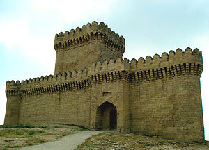
Historical monumentsBayil Castle
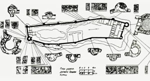
The historical monument that located near to Bayil cape of Baku city and presently remained at the bottom of the sea waters. Being one of the most beautiful works of the Shirvan-Absheron architectural school and built in the XIII century, Bayil Castle sometimes comes to surface by rising and lowering of the waters of the Caspian Sea and somitimes it disappears. Though the Castle was named differently in various sources (Underwater City, Bayil Stones, Sabail Castle, Caravansarai, Khanagah, Komrukkhana etc.) its name in scientific literature is used as “Bayil Castle. Bayil Castle, according to the shape is oblong as per shape of island. Castle’s length is 180 m, average width is 35 meters. East of castle walls was fortified with six and in the west with five semicircular (such as the Baku Castle) towers.
Construction of Bail Castle was completed at time of political-military turmoil in the Middle East caused by Mongol invasions (years 1234-1235). However, the life of this magnificent castle, which was built on island close to the shore, was too short. According to scientists, in 1306 as a result of strong earthquake, it was sunken into the sea.
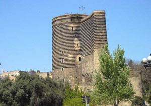
 Maiden Tower
The height of 28 m, a diameter at the ground floor is 16.5 m. The wall thickness at the ground floor is 5 meters. The inner side of the Tower is divided into 8 floors. Each floor was covered with dome-shaped ceiling built of hewn stones. The Tower began to operate as a museum since 1964, and in 2000 it was enlisted in the UNESCO World Heritage list.
One of the emblems of Azerbaijan, the Maiden\'s Tower was described repeatedly on banknotes and coins of Azerbaijan.
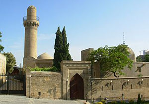
 Shirvanshah Palace
In 2000, it was included in the list of the World Cultural Heritage together with the Old City and Maiden\'s Tower, by the UNESCO.
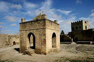
 Temple of fire – Ateshgah
The Temple of Fire Ateshgah is located 30 km from Baku, in the south-eastern part of the settlement of Surakhani of bsheron Peninsula. Ateshgah was built in the place of eternal unquenchable fires in VII-XVIII centuries, at place of natural gas outlet. The earliest construction of the temple, stable relates to 1713 AD, and the central temple-worship was built on funds of merchant Kanjanaqara in 1810.
Surakhani Ateshgah consisted of the temple itself, cells of Indian pilgrims and rooms. Ateshgah was built by local craftsmen on the plan of Indians, who ordered this monument.
In general, Ateshgah looks like city karvansaray for its structure. For its architectural style the monument reflects Median time fire worships widespread in Azerbaijan. However, it retained the features of some Indian temples.
 Ramany Tower
It is a Tower related to XVI century and located in Ramany village of Baku. The height of Tower is 15 meters. The exact date of construction of the Tower, which was built of white stone, is unknown. Perhaps, it was built for defence purposes and was used as a castle at time of Shirvanshah State.
Historians have noted that there was underground road from Ramany Tower to the Maiden Tower.
 Mardakan Tower
It is ancient fortress in the Mardakan settlement of Baku city. The tower was built in four-cornered shape in the middle of XIV century by Shirvanshah Akhsitan son of Shirvanshah Manuchohr. Mardakan Tower was erected in honor of the bright victory of Akhsitan on enemies. Tower was used for purposes of shelter of feudal and as watching point.
The Tower’s height is 22 meters, its thickness from below is 2.10 meters and 1.60 meters at the top. Its inner yard is 28x25. The tower was divided into 5 levels from inside.
 Shikh Tower
The tower, which was built at height of 16 meters in Mardakan, was almost exclusively used as watch point. Mardakan people call it as Light tower. According to the historical sources, the area of location of Tower is a land belonging to Sayid Abdukheyr sheikh. Therefore, the name of building was initially as Sheikh, then Shikh tower, and finally after distortion by local people it is named as Light (Ishiq) Tower. It is noted that the date of construction of building is 1232, and it was built by Masud oglu Abdulmajid.
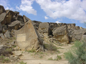
Gobustan
It is located in Gobustan settlement of Garadagh district, 56 km from Baku. The area is approximately 3-4 km.
One of the world\'s most ancient and rich historical monuments of Azerbaijan is well-known Gobustan rock depictions. There are many rock drawings, camps, settlements, graves and monuments etc, of the Stone Age, witnesses of the past of great people of Azerbaijan in Boyukdash, Kichikdash, Cingirdag, Sıkhqaya, and Sonqardag mountains of Gobustan. One can meet monuments of all periods from the Mesolite to Middle Ages in the territory of Boyukdash.
 Stone plastic of Azerbaijan - the ancient historical monuments
Monuments made of stone and decorated stone in Azerbaijan dates back to the remote history. Engraving, carving, scratching over the stone, carved images were discovered by our scientists in Ordubad (Gamigaya), in Absheron (Mardakan, Shuvalan villages) and 60 kilometres south of Baku on the Caspian Sea, on the rocks of Gobustan.
Agoglan castle complex
This historical monument is situated in the village of Kosalar and belongs to the period of Caucasian Albania of IV-IX century. The castle complex is situated at the foot of the mountain. There is the ancient “Watch tower on top of the mountain. For the first time in 1985 information was obtained about underground passage from fortress to Agoglan» castle. However, traces existed inside of underground passages of this castle were not found in the period prior to the Armenian occupation. But the Armenian archaeologists have discovered in 2009 three wells for passing to this passage.
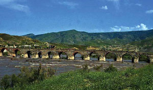
Khudaferin bridges
Historically, it is located in the territory of Jabrayil region that unites the south and north of Azebaijan, which is currently occupied by the Armenians. Khudaferin is great architectural historical monuments, which is the ornament of history of Azerbaijani architecture. It is known about two Khudaferin bridges over the Araz River. The first of them is called Main Khudaferin bridge”, its length is 130, width 6, and height is 12 meters. The second bridge is with 15 spans and the length of 200, a width of 4.5 meters and a height of 10 meters. It is expected that the Main Khudaferin Bridge is the oldest one. Thus, it is assumed that this bridge was built from wood during Ahamanids Empire and later coated with stone and bricks during Eldagizids state. H. Kazvini writes that the Khudaferin Bridge had been built in 736 Greg. by man which was close to the Prophet Muhammad, by Bakir ibn Abdullah. There are assumptions that as if Khudaferin Bridge was built by Alexander the Great, or by Roman commander Pompey. The bridge was of great importance in development of economic and cultural relations of Azerbaijan with countries starting from India to the Near and Middle East countries, Russia.
 Alinja Tower
Historical monument in the territory of the Republic of Azerbaijan. It is the most beautiful examples of Nakhchivan-Maragha architectural school.
In written sources starting from X century its name was Alıncaq, Alancıq, Alinjek and Alinja is located on the right bank of Alinja River, on the steep mountain at the edge of the road-Nakhichevan-Julfa.
There are different opinions about the history of construction of Alinja. Some researchers, based on the historical sources relate the tower to about 2 thousand years ago. In Epos Kitabi Dede Gorgud Alinjaqala is described as a strong fortification. The name of Alinja in the medieval age sources related to castle, mountain, and river.
Though Alinja for centuries served to various ruling dynasties of Azerbaijan and the Middle East, but in history it is known as the headquarter and place of treasure of Atabeyler dynasty, and it surprised even great conqueror Amir Teymur with such strength, that defeated the most powerful military forces of the age.
Spanish diplomat, Ambassador of Castilia king Enrico III in Teymurids duing 1403 – 1406 Rui Qonsales Clavijo described Alinja castle as: Alinjqala located on the high and steep mountain and surrounded with walls and tower. Within the walls, there are vineyards, gardens, plains, pastures, springs, and pools downside of the mountain slopes. The castle or fortress is located on the top of the mountain.
Though after Sefevids it was seriously damaged, the fortress carried out its function in the XIX century.
Momina Khatun Tomb
Momina Khatun tomb is masterpiece of the famous architect Ajami Nakhchivani and the most valuable monuments of the architectural school of Nakhichevan – Maragha. It is located within the Atabek Complex of Architecture in Nakhchivan city\'s historical centre. Momina Khatun tomb is the only monument from that complex which reached us. On the top of body of the tomb, in the writings above – in the main book of the monument, it is written: ... this tomb was ordered to be built by educated in the world, just and great victor Shamsaddin Nusrat al- Islam and al Muslimin Jahan Pahlavan Abu Jafar Muhammad ibn Atabay Atabay Eldagiz ...for the memory of religion in the world, Islam, and fame of the Muslims - Momina Khatun!...
Baaz Tower
Baaz Tower is located 3 km to the south-west of settlement Kaleybar of the South Azerbaijan, Garadagh province. As it was the shelter of the head movement of Khurramids Babek, it is recognized as Babak Castle.
During the archaeological excavations in the territory of Baaz castle the coins of the Byzantine and Atabay Eldagezids states were found. Nowadays on birthday of Babek every year in Southern Azerbaijan under the leadership of Organization of National Awakening Movement south Azerbaijanis march to Tower to commemorate the national hero.
Erk Tower
It is located in the city of Tabriz. It was built by Hulakiler (Elkhanids) in XIII century by Alishah vizier.
Being equal to “Medain palace” Tabriz Alishah castle (Erk Tower) was largest Muslim construction of the age. The monument was restored several times but presently it faces a threat of destruction. The reason is the big mosque built in front of Tower. The newly built Azman mosque made Erk invisible. While watching from three sides the Erk becomes invisible and only when watched from fourth side, the famous tower - the symbol of Tabriz will be visible.
Shamakhy Tower
Shamakhy Tower is a medieval fortress built to defend the city of Shamakhy. During XI - XII centuries, many of the cities of Shirvan, expanded, and defence systems of some of them were re-established. In 1045 Shirvanshah Gubad (1043-1049) had built a wall from white hewn stone sin the main city of Shirvan – Shamakhi and installed iron gates.
The remainder of the wall found by archaeologists during the excavations in Shamakhi during the Azerbaijan SSR was remains of Ichgala Tower built by Shirvanshah Gubad in Shamakhy. During this age new palace complex of Shirvanshah was built in Bala Tower. The second inner fortress of Shamakhy – Gulustan Tower was also re-constructed in the XII century and fortified. After such a wide range of construction works writers of that period called Shamakhy city, which turned to complete capital city, as iron door, stone walled impregnable fortress, beautiful city with wealth and comfort.
Koroglu fortress
It is located in Gadabay region in the village of Qala. It was built from local stones, crudely, but built grandiosely. The fortress is located on the high mountainous area. It is believed to be the main shelter of Koroglu in Azerbaijan.
Askeran fortress
Askeran fortress is located in 24 km of Shusha, 5 km of Khojaly and 12 km of Agdam, in the south, on the left and right banks of Qarqarchay, at foothills of mountain. Here the mountains reach the river with a width of approximately 500 m to the valley and not so big valley encircled with the walls of the fortress.
The construction date Askeran fortress and the name of its builder were written differently in different sources. Some historians relate the construction of fortress to name of Mehrali Khan Garabagly, the other part with the name of the Ibrahimkhalil Khan. At the same time the history of construction is different, too. In fact, Askeran fortresses were built in 1783-1784.
Javanshir fortress
It is located in the territory of Ismayilli region. The fortress built during the reign of the dynasty of rulers Mehranids in the Caucasus Albania bears the name of Javanshir. It is likely that the fortress was used as the administrative centre. The fortress is located 4 km north of the village of Talistan of Ismayilli region, on the right bank of Agjachay. It consists of the main part and inner fortress. The thickness of south wall of main part is 2 m, and height is more than 10 m. It was built with irregular multi-corners and located on the highest place of mountain. Width of fortress in the north end is 2 m and the length is 50 m with protrusion of the wall. Wall is completed with cylinder shaped tower. It is defensive fortress. It is assumed that there is underground way to “Maiden Tower, which is located approximately 7 km from the fortress. Rare flowers and decoration trees not found anywhere grow in the in the yard of the fortress. As a result of landslides in the western walls of the fortress, it was destroyed. The area is about 2 ha. There are 6 towers of diameter of 8 m in the fortress tower. To go to fortress one need to go on car up to the village of Talistan, and 4 km from village to fortress on foot or horse.
Gulistan fortress
It is located in territory of Goranboy region. Though it was reached our time in full but it some towers were survived. The construction date of fortress is related by scientists to the era of Caucasian Albania. The fortress built of local stone was a solid defence structure. Historical Gulistan Treaty was also signed in this fortress.
There is a reservoir and ruins of the fortress building. As well as the private road leading to the river was recorded there.
Chiraggala
It is located approximately 20-25 km from the Shabran region, at the top of the steep rock called Janaqqaya. According to scientists, Chiraggala was built by Sasanian kings in order to defend the fortification in IV-VI centuries. It was main watching point of Gilgilchai Fence. It played as well as the role of the fortress and was one of the three fenced stretched from the Caspian Sea to foothill of Baba mountain. Three of them remained intact.
Azykh cave
It is located in the south-eastern slopes of Lesser Caucasus Mountains in the south-west of the Azerbaijan on the left bank of the Guruchay River.
The cave in the territory of Khojavand region.
Unfortunately it is to be noted that the Azerbaijani territory of location of the cave of most ancient people of the world is under Armenian occupation since 1993 and there is no information about the condition of cave after occupation.
The cave area is 800 sq. m. There are 8 corridors, which stretches to the length of 600 meters. The height of some of corridors is 20-25 meters. As the largest cave discovered in the Caucasus Azykh cave draws the attention.
The world has very little information about the Azykh cave. Because no opportunity was given to former Soviet scientists having researches in this cave, to have contacts with their colleagues living in foreign countries. As a result, the world still knows very little about one of the world\'s most ancient people who inhabited the territory of Azerbaijan.
In 1960 an expedition led by Azerbaijani archaeologist Mammadali Huseynov Azykh cave and began to take on the curtain. It became clear that the cave was a settlement for the world\'s most ancient inhabitants (called them Azıkhantrop). In 1968, as a result of long cave excavations by M. Huseynov the lower jaw bone of Neanderthal man discovered from cave. After studies on finding it became clear that he had at least 350-400 thousand-years of history.
Tomb Diribaba
Two-storied tomb in Maraza village of Shamakhy region, built in the foothill of mountain. Diribaba Tomb Diribaba also functions as the memorial mosque.
For its original image of the architectural, uniqueness of structural composition and connection with nature this monument has a special place in the history of architecture. In the decorative writing lines, which separate floors of the building, the date of monument shown as 805 (Greg 1402).
Gamigaya Drawings
Rock drawings in the Garangush pastures of Nabi area at the southern and eastern hills of Mount Qapıcıq of Lesser Caucasus Mountains of Mount Ordubad.
Archeologists had discovered ruins of native places of grandfathers of Azeri Turks in the area of carving of rock drawings in Garangush meadows, and defined that Gamigaya-Qarangush meadow rich with the Alpine meadows was one of the hunting centres of inhabitants of Nakhchivan. Images in Gamigaya and ancient dwelling places have at least 5-6 thousand years of age. As a result of studies the life of people who lived there, and cultural development were studied. Gamigaya drawings have been studied since 1968.
Ganjasar temple
The Christian Albanian monastery of XIII century located in Vangli village of Agdere region, on the left bank of the Khachinchay. Monastery was the residence of centre of the Albanian Churches in the Middle Ages. During 1991-1994 as a result of I-Karabakh war the area of location of this historical monument currently occupied by Armenian armed forces.
From epigraphic inscriptions on stone of the walls on the temple it is known that this monument was built by the ruler of the high and the vast country of Artsakh, the Albanian ruler of the region, the great grandson of Boyuk Hasan, son of Vakhtang, Hasan Jalal Dovla and his mother Khorisa Khatun in the 1216-1238. Since the early eighth century the area of location of Albania Catholicos, the mountainous part of Karabakh was named Artshakh or Artsakh in the meaning of princedom, ruling. This is not accidental, because the rulers of Arshakids dynasty of kin of Tsar Vachag 1, came to power in Albania in the middle of the 1st century, named self as “arshakh” and rulers of Mehranids dynasty ruled the country from VI to VIII centuries named self as “aranshakh”.
Inside the church in upper parts of the arches were decorated with bas-reliefs of ox and sheep heads, which is considered as sacred. Architectural planning of temple complex and composition solution and samples of sculpture and elements of diophisite nature prove that this monument belongs to monuments of architecture of the Caucasian Albania with centuries-old traditions.
Kish temple
Albanian temple located in the territory of Azerbaijan, in Kish village,
According to legend religious brother of the prophet Jesus, Holy Jacob had sends holy Elysee to Albania to promote Christianity. After the missionary in the Chola province, Elysee comes to village Kish in the Uti province builds there a temple. Famous Kish temple, being popular not only in the territory of the Caucasian Albania, but in whole Caucasus, was the first Christian, which is located currently in the village of Kish.
In the past, there was inscription that temple is of holy apostolic church Elysee and in 1244 it was rebuild by the Albanian Church archdeacon Seraphim. In the 30-es of the XIX century by the decision of the Albanian church Synod after it has been abolished officially, like many other Albanian temples the inscription of this temple was also erased.
This temple for centuries was the religious education centre of the Caucasian Albania. Interestingly, the village, where the temple is located is till called Kish over 2000 years in the meaning of religion, faith, worship.
Yukhari Govharaga Mosque
It is one of the buildings having the dominant position in the architectural ensemble of the central square of Shusha.
Upper Govharaga mosque was built in 1883, and the Lower Govgaraga mosque nearly eight years later by architect Karbalayi Safikhan Garabaghi at the expense of. Govgar aga.
Research shows that the present location of the mosque during the period of Panah Khan there were reed mosque. This mosque built by Panah Khan was replaced by the stone by Ibrahim Khan in 1768. That mosque also had a poor appearance without minaret. It appears that this view of the mosque was not liked by his daughter Govhar aga and therefore that mosque (XIX century) was completely destroyed and replaced with a new mosque with twin minarets. As it is known, however, this mosque was also destroyed by instruction of Govhar aga and the building, which is known today as Upper Govgaragha mosque, which reached our days, was built in its place.
Shamkir Minaret
Shamkir minaret is the masterpieces of Azerbaijani architecture. This minaret once located in the place of ancient city amused travellers till the second half of XIX century but later it was destroyed and it a unique Azerbaijani monument that studied from the images and paintings.
To imagine the structure and size of the minaret fully notes of N. Florovski in book printed in 1899 in St. Petersburg are valuable. This monument is one of typical minarets of the Great Seljuk Empire, in its different cities, a type, which is built near Friday mosque, and also standing - complete separately.

|