Home page
» GEOGRAPHY
» Physical Geography
» Climate
Climate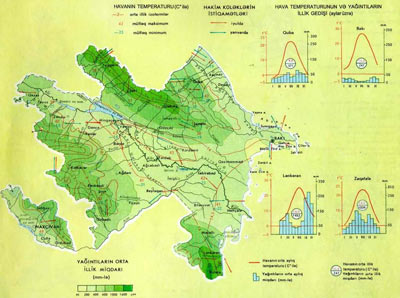 Climate
The Caspian Sea impacts the climate moderately.
The scientists of Azerbaijan proved that named the country as sunny Azerbaijan not in vain. The sunny hours in republic varies between 1800 – 2900. The highest figure is in Araz plains of Nakhchivan 2900 hours / year. In Aran, Absheron and Jeyranchol is makes 2200-2400 hours / year.
In areas with high clouds the active temperature is less. For example, in Lankaran and Shollar plains it is 1800-2000 hours / year. In the mountainous regions - 2200 hours / year, in the mountains of Nakhichevan - 2500 hours / year.
When the average annual temperature of Kur-Araz lowlands is +14.5 ° C but in peaks it is less than 0 °.
The lowest air temperature in republic was observed as -45 ° C in the high mountains. This is considered the absolute minimum. In Araz River Gorge - 32 ° C was recorded. The absolute maximum is in Julfa +44 °C. In Kurdamir it is +43 ° C, in the foothill zone - 37-40 ° C, in Lankaran - 35 ° +38 ° C.
The annual temperature amplitude is more than 50 ° and 60 °. Daily amplitude along the Araz plain and in Aran is 11 ° -13 ° C, in Ganja-Kazakh - 7 ° -8 °C.
1) Continental Arctic air mass is formed on Black and Barens Seas. It comes mainly from the North Arctic Ocean in the winter and its snows a lot. After reaching the Greater Caucasus it is divided into two and enters Azerbaijan from the east and west.
2) Marine Arctic air mass is formed over Spitspergen and Greenland islands, and enters throughout the year from two directions. At the end of winter and beginning of the spring a big snow snows. Clouds get increased and air gets cool, precipitation increases.
3) the Atlantic or the warm sea air. Starting from Azores maximum passes over all of Europe and enters overt the North Caucasus and the Black Sea. The temperature falls below and rains more. It enters more at the end of spring and beginning of the summer.
5) Tropical air mass. Starting from North Africa and the Arabian Peninsula it enters from the territory of Iran, the south. It is mostly felt in Kur-Araz lowland. It raises temperature in the winter, and brings dry and hot air in summer.
6) South cyclonesenter over the Mediterranean, north-west of Iran, Asia Minorr. Resulting in falling of much precipitation in summer.
7) Middle Asia air mass passes over the Caspian Sea. Increases the temperature in the hot period, decreases in winter. More precipitation falls in Aran in winter. Winds blowing from the south-east pass over the Caspian Sea and collide in Talysh mountains and forms aerographic precipitation.
The winds formed in Azerbaijan are divided into two parts by origin:
1) Those entering from outside:
- Khazri is the north wind. The strongest wind - speed 35-40 m / sec. Brings cool in the hot summer. It blows from the north-east and north-west;
- Gilavar is the south wind. It may blow from the south-eastern and south-west. It is a hot wind. It has warming impact in winter.
2) The winds formed locally: Breese on the Caspian coast, the winds blow in the mountains and valleys. Fyon wnds are form between mountain and plain in winter.
In Aran white and black storm, Araz silyanı, blizzard, Afat, rahmani winds blow in hot time.
For the wind Absheron is at first place, Kazakh-Ganja is at second place and Guba- Gusar at third place.
Precipitation mostly fall in southeast of Talish Mountains. In the Greater and Lesser Caucasus precipitation increases by climbing up.
For the annual amount of precipitation the south of the Great Caucasus is at 2nd place after Lankaran. For the amount of annual rainfall the Lesser Caucasus occupies the third place.
9 out of 11 climate zones are observed in Azerbaijan. It is possible to group these climate types in 4 groups:
a) semi-desert and dry steppe climate covers more than 50% of Azerbaijan. It belongs to Aran, Samur, Araz plains.
1) The semi-desert and dry steppe climate with mild winter, hot summer covers the Kura-Araz lowland. This is known as the dry subtropics.
2) semi-desert and dry steppe climate with cold winter, hot summer was formed in Nakhichevan Araz lowland and partly at low mountains.
b) warm-temperate climate covers 30% of Azerbaijan. It dominates at the Greater and Lesser Caucasus, Talysh, low-and middle-mountainous parts of the region.
3) warm-temperate climate with dry winter covers the slopes of the Lesser Caucasus, Ajinohur, Gamkh-Ayrichay and the Greater Caucasus’ south-easti. The average temperature in is July +22 ° C, rand ainfall is in autumn, at the end of summer.
4) warm-temperate climate with dry summer spread in Lankaran lowlands, south-eastern edge of the Lesser Caucasus and south-east of the Great Caucasus. More precipitation falls in autumn.
5) the mild-hot climate with equal distribution of precipitations throughout the year covers the Talish Mountains, south of the Great Caucasus and North-East, low mountains and foothills zones. It\'s raining throughout the year.
c) cold climate covers 20% of Azerbaijan. It is dominant for the Greater and Lesser Caucasus, as well as the middle, partly high mountains of Nakhichevan.
6) A cold climate with dry winters starts from low mountainous zone in Nakhichevan and extends till the high mountains.
7) A cold climate with dry winters is specific for north-eastern flank of the Greater Caucasus (Yan range), high mountains of the Lesser Caucasus. In the middle mountainous regions, the average July temperature is +15 °, +20 °C, at high mountains is +10 °, +15 ° C.
8) cold rainy climate in all seasons with plenty rains is observed in the south of the Great Caucasus. Precipitation falls mostly in spring and autumn.
9) The upland tundra climate is observed in the Greater and Lesser Caucasus, partly in Zangezur range

|